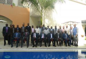
The Third Meeting of the Steering Committee of the JPO in Addis Ababa

Posted on: April 09, 2018


The  3rd Meeting of the Steering Committee of” EGNOS in Africa “, Addis Ababa, EThiopia 

On the 5th of December 2017 in Addis Ababa, Ethiopia, the 3rd Meeting of the Steering Committee gathered 23 participants from AUC DIE, EUDEL AUC, EC, AFCAC, ICAO, ACAC, ASECNA and regional economic communities among which ECCAS, EAC, IGAD, ECOWAS, COMESA.

This 3rd Meeting was co-chaired by EU Delegation to the AU, Mr. Francisco Carreras Sequeros, Head of Cooperation and Mr Cheikh Ould Bedda, Director of Infrastructure and Energy of the African Union Commission.

This intensive one-day but fruitful working session enabled SC Members to address the various aspects of the work programme and to make the necessary recommendations to fast-track the implementation of the Action, this as per their main mandate to oversee and validate the overall strategic direction and policy of The Action “Support to the Joint Programme Office (JPO)” . 

The DIE called for the SC to give new impulse to the Action while accelerating the implementation of the Recommendations of the AU Specialized Technical Committee on Transport, Transcontinental and Interregional Infrastructure, Energy and Tourism (STC-TTIET) in Lomé, among which focusing efforts on the conduct of the continental CBA study and strategy, for which a Task Team is being setup by AFCAC. 

While commending the significant progress achieved by the Action and the contribution delivered by the JPO towards implementation of its programme, the DIE called for the Meeting to focus on the implementation of the recommendation n°7 of the STC-TTIET Declaration of Lomé, which will be supported through the creation of an AUC Working Group under the Sub-Committee on Transport to oversee, among others the issue of the institutionalisation of the JPO. 

The 3rd Meeting was also an opportunity for all RECs to exchange and share their experience regarding advancement of the Action at their respective Modules level while discussing initiatives such as ASECNA’s Phase-B studies.The Next Meeting of the SC is scheduled in May 2018 in Brussels. 


Background information

The Pan-African (PanAf) Programme constitutes one the main financial instruments of the European Union (EU) for the implementation of the Joint Africa-EU Strategy (JAES). Funded from the general budget of the EU, it is the first ever EU programme in development and cooperation that covers Africa as a whole. Aligned with the Roadmap 2014-17 adopted at the 4th Africa-EU Summit held in Brussels in April 2014, the first phase of the PanAf was launched in July 2014 to fund projects for the period 2014-17. The Annual Action Programme 2015 of this PanAf includes the EGNOS in Africa Support Programme, whose Action, referred to as “Support to the Joint Programme Office (JPO)”, is co-funded by the European Commission and ASECNA.

The overall objective of the Action “Support to the JPO” is to contribute to the improvement of aviation safety in Africa, taking also into consideration non-aviation applications of satellite navigation, thus contributing to economic and social development in Africa. The specific objective of the Action is to accelerate the adoption and development in Africa of satellite-based augmentation systems (SBAS) based on the European EGNOS programme, primarily for the benefit of the civil aviation sector in order to improve safety and flight efficiency at acceptable costs.

Steering Committee

Tasked with providing the Action with overall policy and strategic direction, the Steering Committee (SC) is co-chaired by the European Commission and the African Union Commission, with the JPO acting as Secretariat. The SC includes representatives of the African Civil Aviation Commission (AFCAC); The International Civil Aviation Organisation (ICAO); Regional Economic Communities (RECs): EAC, COMESA, IGAD, ECOWAS, ECCAS, UEMOA and SADC;The Arab Civil Aviation Commission (ACAC);ASECNA; The European GNSS Agency (GSA).

 Courtesy of JPO

EGNOS-Africa and Land Asset Management

Posted on: December 22, 2017


EGNOS has been mainly designed, built and operated to fulfill the strict requirements set by the International Civil Aviation Organization (ICAO) in the air traffic sector. It improves the accuracy of GPS and provides in addition an integrity message for safety of life applications.

Quickly the use of EGNOS has been extended to other mobile users, like trains, trucks, vessels, cars, agricultural machines and more recently drones which mainly benefits from the augmented accuracy ;this augmented accuracy could also serve many others applications. Geolocalizing easily and precisely fixed objects in their environment, with a cheap receiver, can have a great value. Most of the time we simply talk about” mapping” but, in some cases, it’s more than mapping, it can be a real land asset management service.

 With an horizontal position system error of 95% percentile at 2 meters even under high scintillation condition, we can identify three main domains for these kind of applications based on EGNOS:

  • large scale asset management
  • parcels and cadastral activities
  • utilities companies

Use of EGNOS in large scale asset management

In each country, public work departments have large land assets to manage. They are right-of-ways of roads, railways and waterways. This land domain is full of objects which are important for providing a good level of service. Traditionally, bridges, retaining wall, culverts, ditches, signaling posts are localized by a curvilear abscissa measured along the centerline and a transverse measurement perpendicular to the axis. Due to multiple sources of errors the final position is more lager than a couple of meters. The process could be simplified ad improved by the use of an EGNOS receiver that will provide better than two meter accuracy in real time

Use of EGNOS in parcels and cadastral activities

The localization of parcels in rural or peri urban environment is some time a complex, expensive and boring process. The naming of streets and postal addresses rarely exists in Africa. Most of the time localization and measurement of parcels require low accuracy. Using parcel boundaries data provided by an international, independent SBAS service provider would facilitate cadastral management by regional and local authorities and guarantee a better respect of ownership right. It’s worth also to mention that in remote places the international borders are still subject to discussion.

Use of EGNOS by utilities companies

Waters supply pipes, sewage pipes, electricity power lines, telecom lines are complex networks that must be maintained and repaired quickly in case of disturbances. Precise geo localization of undergrounds pipes, meters, manholes and stop taps are very helpful for maintenance teams that are to intervene on the field.         

Perspective

Providing that the receivers’ industry elaborate dedicated cheap and robust receivers to these applications, SBAS services in Africa based on EGNOS can contribute in growing the use of GNSS. Widely available free accuracy will benefit real time mapping solutions. Today, most new GNSS devices are EGNOS-enabled, permitting real-time accurate positioning but they are not tailored to African conditions and land asset management needs.

These receivers must be fully designed to suit African conditions and be dedicated to this application to avoid any misappropriation. It must also have an interface to easily down load the data in a data base for future reused and automatically assign a linear position (curvilinear abscissa) to positioned objects, if still needed.

Embedded in an electronic tablet, the GNSS and SBAS data can support professional modules like electronic events ledger to record the damages on the infrastructure or automatic calculation of quantities to pay a contractor.

A hand book and training carried out by experienced professionals will make the tool user friendly.

Moreover the market approach should take into account the future arrival of EGNOS V3 with its multi-constellations and multi-frequencies features which will open broad perspectives for these applications of high interest for Africa.

Roger PAGNY senior expert in ITS and GNSS

Roger Pagny graduated from the National Civil Engineering School (Ecole Nationale des Ingénieurs des Travaux Publics) in 1973 and obtained a post-graduate degree in economics at the Political Science Institute in Paris in 1981. After extended stays in Africa and the Asia-Pacific zone, Roger Pagny joined the Traffic and Road Safety Department in 1995 to take charge of French participation in European ITS projects. In 2002, he was appointed to highlight the interests of the Ministry within the steering bodies of the European satellite navigation programs EGNOS and GALILEO.

As head of the satellite applications office, he was project manager for the Ministry’s satellite applications plan, member of the Galileo Compatibility Signals Interoperability working group and a member of the Galileo Commercial working group. He is now vice president of ATEC-ITS France, a non profit association in charge of promoting innovation among the transport sector.


The Civil Aviation response to GNSS vulnerabilities

Posted on: December 19, 2017


Vulnerabilities

Interference. GNSS core signals are transmitted from Medium Earth Orbit constellations at 20 000km above the earth and thus reach users receivers as weak signals. Although the spread spectrum nature of these signals provides some natural protection to interference, the earth interference power to space signal power ratio is frequently unfavourable and this has to be addressed as a first type of GNSS vulnerability.

Space weather. When aiming to provide precision approach services, GNSS solutions such as SBAS and GBAS do provide additional corrections to core constellation signals, in particular through modelling and correcting of the ionospheric layer disturbances impacting the core constellation signals. These ionospheric disturbances are highly dependent upon the solar activity, and therefore Space weather represents a second type of GNSS vulnerability.

Cyber security. Finally, as other information carrying systems, a third type of vulnerability is system intrusion which has to be addressed through appropriate cyber security layers.

Mitigations

Interference impact may be practically addressed by States though several actions lines such as e.g. : enforcing an efficient spectrum policy and regulations against unlawful interference sources, designing a State intervention policy against illegal jammers, designing a State cooperation process to limit the impact of e.g. Defense jamming activities over communities using GNSS services.

Space weather impact has mostly to be addressed through GNSS system design. This involves several ranges of activities such as collecting and analysing data, defining worst cases, defining system mitigation strategies (such as algorithm tuning, scintillation reduction, geo ranging deployment, etc…).

Cyber security policy has to be designed with respect to a set of agreed threats and vulnerabilities, which are usually addressed at restricted State level, and then system mitigations are requested to be implemented at system level.

Alternative means

When GNSS is used as a primary means of navigation or time stamping source, the implementation of typical mitigations as above described allows GNSS to support a high percentage of availability. When additional availability is required (e.g. for Safety of life applications, critical applications, etc..) it is usually requested to maintain or deploy additional service layers which are typically expected to either replace GNSS in the case of mitigation or system failure, or to provide an alternative degraded service, but still meeting the main mission objectives (e.g. for aviation safely landing aircraft following a GNSS loss).

These alternatives layers/policies are often quoted as Alternative Position Navigation Timing (A-PNT) solutions. Typical solutions implemented as of today for aviation include the use of ground beacons networks (ILS, VOR, NDB, DMEs) for continuing navigation in case of loss of, or too important degradation of, GNSS services. Alternative source of datation through atomic clock transmission over Long Waves High Power transmitters supporting ATC or radar data critical time stamping are today implemented within some European States.


Benoît ROTURIER graduated as an Aeronautical Telecommunications engineer from Ecole Nationale de l’Aviation Civile (ENAC), Toulouse in 1985 and obtained a PhD in Electronics from Institut National Polytechnique de Toulouse, in 1995. He also qualified as an Instrument Flight Rules pilot in 1993.  He is now acting as the program manager for satellite navigation systems implementation within Direction des Services de Navigation Aérienne (DSNA). He is also involved in international standardization activities as the chairperson of the International Civil Aviation Organization (ICAO) Navigation Systems Panel (NSP), and French representative of the Performance Based Navigation Study Group (PBNSG).

AATO and EGNOS-AFRICA JPO join forces together

Posted on: June 26, 2017


‘AATO will collaborate with JPO to create standardized training in GNSS (Global Navigation Satellite Systems)’

On the 11-13 April, 2017, Ethiopian Airlines was the host of the 4th International Civil Aviation Organization (ICAO) Global Aviation Training and TRAINAIR PLUS Symposium with the theme: Together, Enhancing Training to Build Capacity”, organized in Addis Ababa and which is the first of its kind to be organised in Africa. It involved State Members ICAO and training organisations across the Continent.

Ahead of this important Symposium, AATO and JPO signed an important cooperation agreement in the form of a MoU to address future needs in terms of capacity building in the global navigation satellite systems domain for Africa, from technical but also on the legal and institutional aspects.

The JPO who participated to the review meeting of the AATO training roadmap was honored to be associated and to take part in this continental wide programme for Africa. To meet training requirements within TRAINAIRPLUS Centers, JPO will be involved in the ICAO TRAINAIRPLUS course conceptions among which one to be held at EAMAC (Niamey, Niger) soon. 

AATO was created following the recommendation 5/8 of the AFI RAN special meeting held in Durban in November 2008, stating that “States, training institutions, service providers, donors, ACIP and AFCAC work towards the establishment and implementation of a framework for harmonisation and standardization of aviation training Africa to maintain high levels of aviation safety in Africa”. 

Says AATO Secretary General ‘Under the terms of the signed MoU, AATO will collaborate with JPO to create standardized training in GNSS (Global Navigation Satellite Systems’).

(courtesy of JPO)


Workshop II – Eastern Africa ‘Building SBAS Services in Eastern Africa and beyond Aviation’

Posted on: June 26, 2017


Dar Es Saalam , 1 – 2 March 2017

On the 1st March of 2017, the Honorable Deputy Minister, Transport, Works and Communications the Republic of Tanzania, Eng NGONYANI Edwin A. officiated the opening this Ceremony of this 2nd Regional Workshop on ‘Implementation of EGNOS Satellite based Augmentation System’ in Eastern Africa .

The 2nd SBAS Workshop ‘s theme in the Eastern Africa was  ‘Building Satellite Based Augmentation Services in Eastern Africa- Beyond Aviation: benefits for Agriculture, Surveying, Maritime, Road, Rail, LBS’while the first Workshop was centered on Aviation, a good opportunity for participants to look outside the box and open their minds to explore new opportunities offered by this new Technology in various other Sectors.

 In his opening address, The Honorable Deputy Minister, on behalf of the Government of Tanzania appreciated the choice of Dar-es- Salaam as the venue of the workshop, welcomed all participants and commended shared efforts between EAC and IGAD Secretariats and JPO towards the organization of this Workshop.  Quoting the Hon. Deputy Minister, participants were invited ‘to re-think he current air navigation system’s capacity and efficiency in Africa to benefit from the agreed establishment of a single African sky and single air transport market, which calls for exploring new technologies among which possibilities for implementing SBAS services in the East and Horn of Africa’. He gave some reference projects in EAC, IGAD and COMESA such as the Upper Airspace under the tripartite agreement, which main objective is to enhance efficiency in the management of the upper airspace to bring down navigational costs to air transport operators and improve civil aviation safety, in line with YD objectives. 

 The organization of this workshop was highly commended by the Hon Deputy Minister as part of the ongoing implementation of the adopted Joint Work Programme (EAC/JPO) and cooperation between IGAD/JPO to support the EAC, IGAD and DRC decision making processes towards creation of the proposed Eastern Africa SBAS Module.  

The Workshop raised high interest from all participants, most of them discovering that SBAS benefits and impact go beyond aviation- providing enormous opportunities in maritime, road, rail, location based services and agriculture.Backed up with intense but constructive panel debates, JPO provided insight on various topics among which the Joint Africa-EU Strategy, the Africa/EU International cooperation on Satellite Navigation and the EGNOS in Africa JPO, an Overview on Satellite Navigation Systems, GNSS and GNSS Augmentation System including GNSS/SBAS benefits for Aviation, in Maritime and other non-aviation applications, GNSS/SBAS Technologies and the world trends, SBAS/EGNOS Initiatives in Africa and SBAS implementation in Eastern Africa which is known as ‘Eastern Africa Module’.As a result, the Workshop concluded with a set of recommendations on the way forward.

 A vote of thanks was delivered on behalf of all participants by one special guest, Dr Elsadig Abdalla, Director, Economic Cooperation and Social Development, IGAD in which he gave a nice story describing evolution of navigation and positinioning ‘technologies’ from old days of his childhood and his techniques as herd keeper to look and find animals, sheep, goats, calves or camels using our common sense and experience where to find our lost animals’. A story we will always remember of Dar Es Salaam Workshop II encounter.

 Representing the Minister of Transport, Works and Communication, the closing ceremony was officiated by the CEO and Managing Director of Air Tanzania Company Limited, Eng. Ladislaus E. Matindi, who after thanking organisers of the Workshop (JPO, EAC and IGAD Secretariats) for their efforts, requested participants to urge Member States in the Eastern African region to back their Secretariats in order to make the SBAS programme a reality. 

Our Vote of hanks to EAC and IGAD Secretariats for hosting in Dar-es-Salaam and co-organizing this 2nd Workshop in Eastern Africa in collaboration with EGNOS Africa Joint Programme (JPO) !

(courtesy of JPO)